Posts

Jicarita Peak: Source of Contested Waters
Image
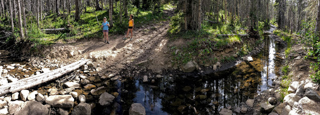
As we started hiking to Jicarita Peak , the 8th-highest mountain in New Mexico, we crossed this acequia (drainage ditch) that captures rainwater and snowmelt flowing down the slopes behind it from the summit of the Sangre de Cristo mountains (we're crossing it here at 10,500 feet). It moves this captured water sideways to the east, out if its natural path to the Rio Pueblo that flows west past the Picuris Pueblo River on its way to the Rio Grande River. Instead, these diverted waters are carried about four miles to the east, to the top of the Rio Pueblo watershed and beyond, where they are allowed to fall down the eastern slope of the mountains to irrigate farmers' fields in the Mora Valley below. The Mora River then flows east to the Mississippi River via the Canadian and Arkansas Rivers. This acequia was built between 1879 and 1882 by some of the earliest settlers in the Mora Valley. In 1882, residents of the Picuris Pueblo sued the settlers for diverting water – that had bee...

Crossing Over the Rim into the Valles Caldera

Image
We hiked up into the lovely Cañada Bonito from the base of the Pajarito Ski Area. It is unique because it is one of the very few high mountain grasslands in the area that has not been subjected to livestock grazing since 1943, when the Los Alamos National Laboratory restricted land use. We reached the rim of the Valles Caldera at the head of Cañada Bonito. The trail turns north and follows the top of the rim through stands of aspen trees, reaching an elevation of 9,600 feet. This fireweed was growing alongside the Pipeline Trail that drops steeply down into the bowl of the Valles Caldera. The Pipeline Road delivered us to the Valle De Los Posos, a misspelling of pozos, meaning spring or well. The circular bowl of the caldera, which is 45 miles in diameter, began to open up in front of us. Thunderstorms from the previous day left puddles, foreshadowing weather conditions later in the day. The domed mountains in the background are the Cerros de los Posos. They w...

The Earliest Evidence of Basketmakers in the Southwest: Falls Creek Valley

Image
Looking across the Animas River Valley, north of Durango, Colorado, to the white, banded cliffs that are above the Falls Creek Valley. In the background are the La Plata mountains with early Spring snow.  These cliffs are designated the Falls Creek Archaeological Area because some of the first dwellings built by Basketmaker people in the Southwest were discovered here. There were dwellings inside rock overhangs at the base of those cliffs and on the slopes below. The rock shelters and caves in these cliffs were first lived in some 2,700 years ago, at the end of the Archaic and beginning of the Basketmaker period. They remained occupied until this region was vacated by Indigenous people around the year 825. People may have preferred to live high up on the side of the Falls Creek Valley because it was warmer there than on the valley bottoms, which collected colder air that tended to sink. These Basketmakers were among the first people in the Mesa Verde region to cultivate maize,...