San Ysidro Anticline: Where the Colorado Plateau Meets the Rio Grande Rift

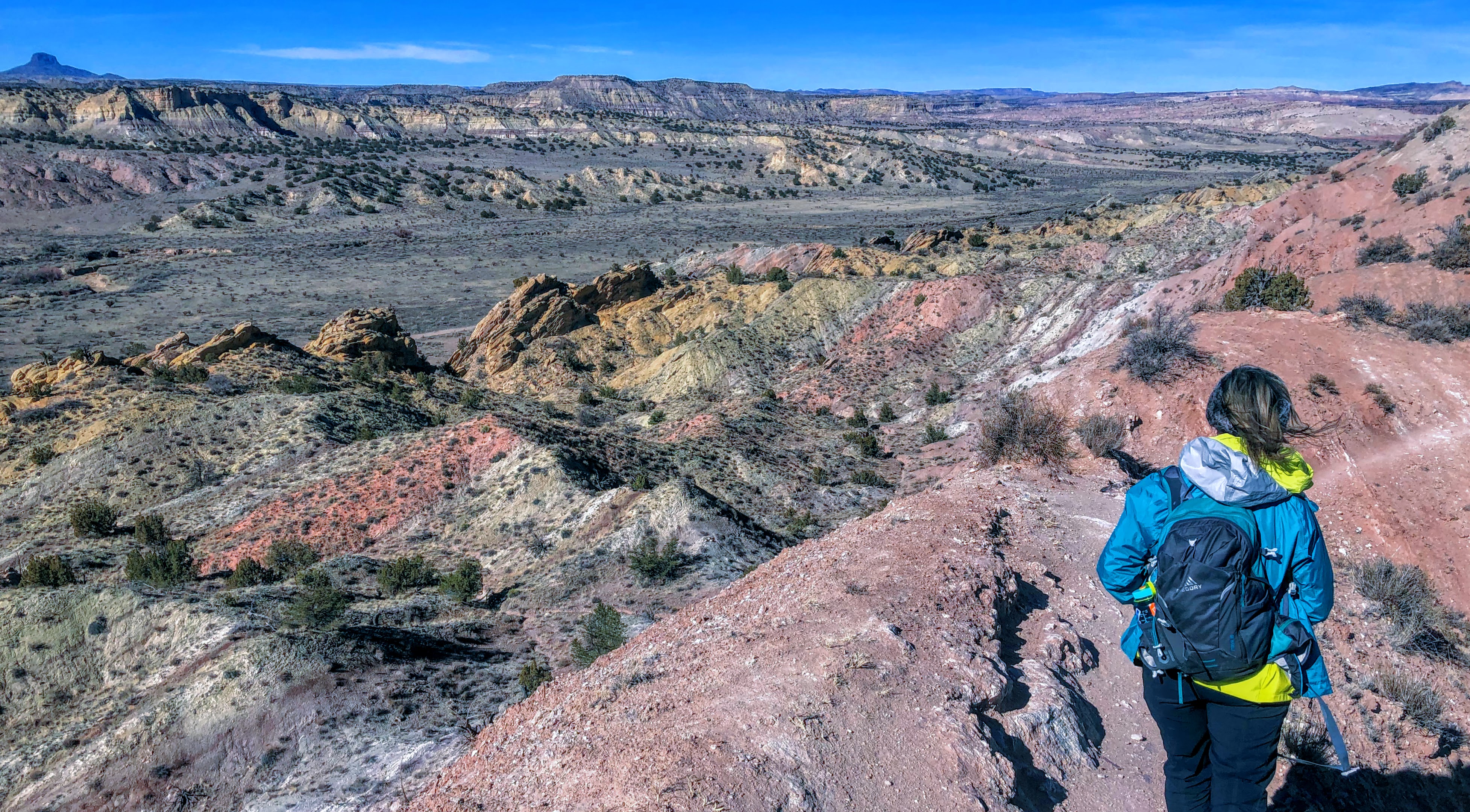
We're about to hike along the south rim of what geologists call the San Ysidro anticline, or alternatively the Tierra Amarilla anticline. Trail bikers call it the White Ridge. Millions of years ago, things looked quite different here: we're peering into a valley that was a ridge, not a low point. The peak of the ridge followed the center of the valley you see here - so the highest part of that ridge is now the lowest part of today's valley.
Geologists call this "inverted topography": the highest parts of the land have been transformed into the lowest parts. How did that happen? The rock layer that covered the top of the ridge was made of shale, limestone, and gypsum. You can see the white gypsum on the trail at the edges of this photo (geologists call it the Tonque Arroyo Member). This hard rock cover was eroded off the top of the ridge by wind, precipitation, and freezing and thawing. As it wore away, much softer sandstones, mudstones, and siltstones beneath it were exposed. They form the red earth you see in the valley. This softer earth eroded away at a much faster pace than the harder layer that had covered it, forming the valley.
The colorful earth you see in the valley is red and green siltstones and mudstones that were deposited on the floodplain of an ancient, mighty river during the Triassic Period, about 205 to 210 million years ago. The river passed close by here, flowing westward from the Appalachian Mountain range to a sea coast in Nevada. It was comparable in extent to the modern Mississippi river.
This land was closer to the equator at that time, so it was tropical. Rivers meandered across flat plains that were close to sea level and were covered with forested wetlands. River deposits formed the red bed shales. Today it is called the Petrified Forest Formation because it contains large amounts of petrified wood. This soil's red color indicates it formed in an atmosphere with a relatively high percentage of oxygen, creating a strongly oxidizing environment that converted (or rusted) the iron in the sediments to bright red hematite.

The trail we are hiking here is called the Dragon's Back. Hikers' feet have worn a groove, exposing the top layer of white gypsum rock. On this west rim of the valley, you can see the flank of the ridge rising to the right to a point where it has been truncated by the erosion that formed the valley, which is just beyond the right edge of this photo.

When flat land is shoved upward, bulging to form a ridge, geologists call the ridge an anticline. The Dragon's Back trail follows the ridge on the left (above), which is the left side of the anticline. The eroded valley to the right of this ridge has replaced what was formerly the crest of the anticline.
The mountains in the background are the Nacimiento Mountains, the southern-most tip of the Rocky Mountains in the United States. They formed between 75 to 55 million years ago when the Rocky Mountains were pushed up because the North American plate moved west and collided with the Pacific Plate.
These mountains are also part of the southeastern-most edge of the Colorado Plateau. So, we are standing on the edge of the Colorado Plateau where the exposed red colored rocks are 250 to 280 million years old. They are from the Permian period when the first animals that lived entirely on land were just evolving. At our backs is the Rio Grande Rift Valley, which geologically speaking is much younger, having formed during the past 30 million years.
Looking down and to the left from the Dragon's Back to the base of the anticline, we could see layers arcing up towards us that had formed the anticline ridge (now eroded away). The same geological forces that lifted the Colorado Plateau and pushed up the Rocky Mountains tilted these colored bands of rock upward at about a 45º angle some 70 to 80 million years ago. Time has eroded away all but the base of this anticline ridge where we see these upturned layers.
The yellow, toothy layers of rock are Entrada Sandstone. It is a solidified remnant of sands that accumulated in the middle Jurassic Period — from sand dune fields, oceanfront beaches, and tidal mudflats. To the right of them are the older red bed shales from the Petrified Forest Formation of the Chinle Group. Looking across the valley to the yellow bluffs in the distance, we could see the same layers of rock that remain horizontal, not having been folded like these into an anticline.
Cabezon Peak is on the horizon at the far left. It is lava that congealed in the throat of a cinder cone volcano, now extinct, 2 to 3 million years ago. It has been exposed by erosion that removed the soft cinders which formed most of the cinder cone peak surrounding it, leaving just the much more resistant volcanic basalt rock of the throat, like the better known Shiprock, 120 miles to the northwest, or Devil's Tower in Wyoming. Cabezon is the largest of about 50 such volcanic "necks" or "plugs" found in this region of New Mexico, and it rises more than 1,000 feet above its valley.

Looking across the valley of the anticline: the tallest peak on the horizon is Redondo Peak, the resurgent dome in the center of the massive Valles Caldera, a volcanic crater with a mountainous rim that measures 45 miles in diameter.
The bright White Mesa in the center distance is a surface mine that exploits an unusually thick and pure layer of gypsum from the Tonque Arroyo Member on land owned by the Zia Pueblo. We'll be hiking the trails on the opposite side of the valley (in the center of this photo) to complete our loop hike.
The gypsum from the mine is trucked to Bernalillo and Albuquerque where it is used to make Portland cement and other forms of mortar, plaster of Paris, and drywall. Since it’s nontoxic, it’s also used as a food additive to improve gelling of foods such as tofu. This is the largest gypsum mine in New Mexico.
In 2005, gypsum miners up there found the fossils of Ice Age animals that included two camels, a horse, a bison, and a deer. A sci-fi thriller called Ghosts of Mars was filmed there in 2000. They sprayed the gypsum with thousands of gallons of red food dye to make it look like Mars, and had to do it several times when monsoon rains washed the color away.
Where did this gypsum come from? During the Jurassic period, 160 million years ago, sea level was up there on top of that mesa — since then the land around it has eroded down by about 500 feet. This land mass had moved north, away from the equator, into the latitudes where great deserts like the Sahara form. This became a desert of sand dunes that was eventually flooded by an open sea to the northwest, in what is now Utah, called the Sundance Sea.
The water had to flow over a shallow sandbar to get here from the sea, creating a warm, moderately deep, oxygen-poor body of salty water — known as a salina — that was isolated from the main body of the Jurassic ocean by a barrier. Eventually it was completely cut off from the Sundance Sea, so lacking a source of water, this inland sea slowly evaporated, leaving behind a deposit of salt. Over time, this layer of salt was buried by new layers of sediments and was converted to gypsum, which is a mix of water, calcium, and sulfur.

This is the view to the east toward where we started our hike at the head of the anticline valley. The Sandia Mountains above Albuquerque are on the horizon. The greyish rocks that form the top of the ridges in the background are shale, a rock made from silt that settled on the same inland sea that had formed the gypsum, plus limestone, which is made from the shells of sea creatures that accumulated on the floor of that inland sea after they died.
This layer is called the Todilto formation. It was deposited in that slowly evaporating, salty arm of the Sundance Sea over a period of 14,000 years. First, a layer of limestone precipitated from the evaporating sea water, followed by layers of clay and dark organic material. Together they formed the Mesa Luciano Member. Later, the gypsum precipitated as the salty waters of the salina became more concentrated by evaporation, forming the Tonque Arroyo Member.

We found a trail that dropped steeply into the valley in the center of the anticline.

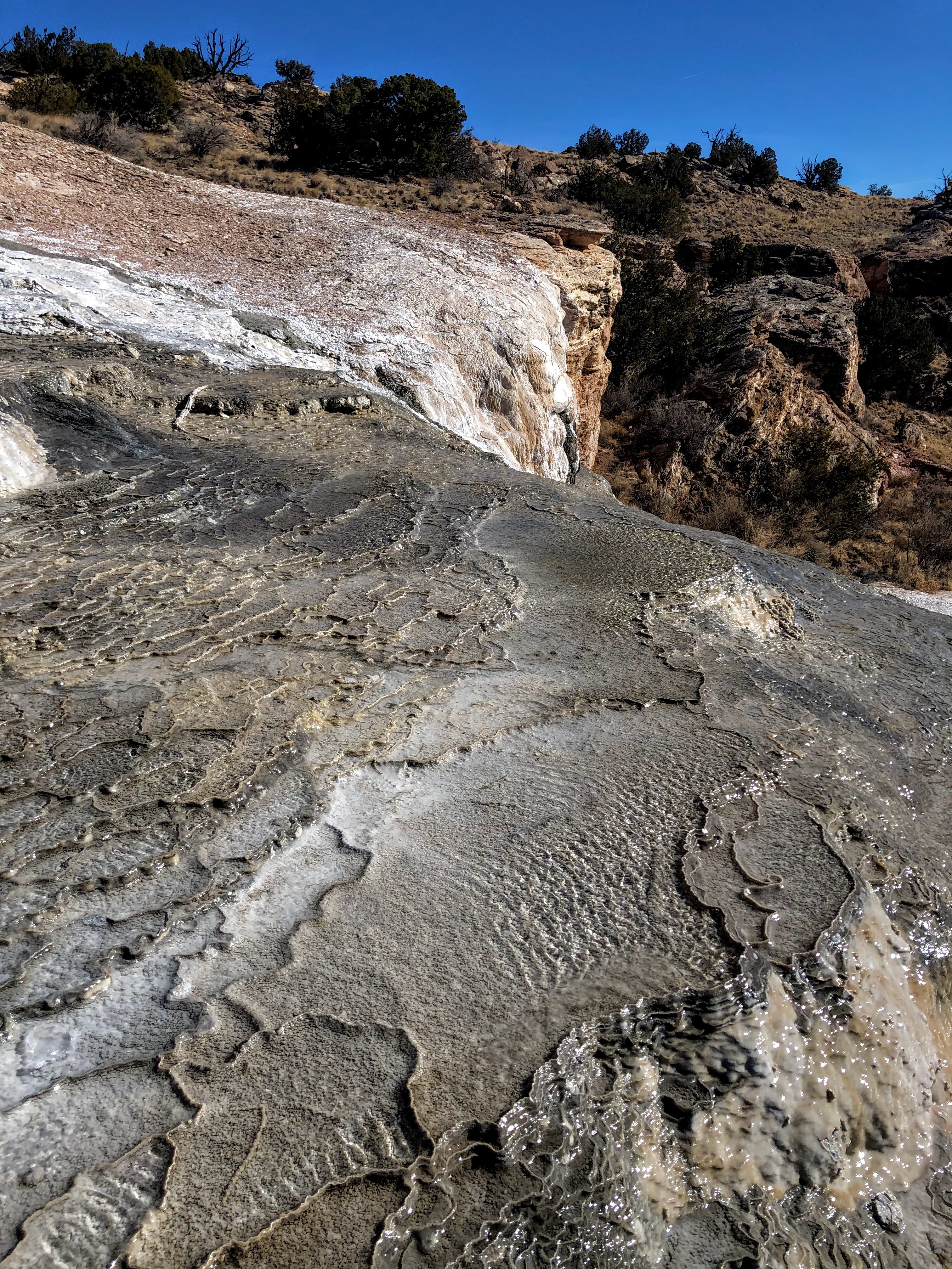
You can see a corner of the gypsum mine in the upper-right hand corner. above. The white deposits at the bottom of the photo are salt deposits left in the valley bottom by water flowing out of springs and from the slope above. You can see a spring just above these white deposits at the center of the photo, where there is some olive-green colored grasses growing on the floor of the valley.
The white deposits on the slope above the valley are caused by hot springs on these slopes that are sending water trickling down to the valley. As the water has come up through cracks from underground, where it has been heated by past volcanic activity, it dissolves calcium carbonate. When this water emerges from the springs, it deposits the calcium carbonate as a form of limestone, creating layers of travertine rock (stalactites and stalagmites in caves are travertine). Salt from the water has crystallized on top of the travertine, giving it a bright white color.
These springs have been flowing and creating travertine for the past 270,000 years, so that it has reached a maximum thickness of 33 feet in places. Layers of this travertine are sliding down the softer, underlying soils of Petrified Forest mudstones, moving from the top of the ridge into the valley below.

Springs form pools that form in the mounds of travertine deposits. These pools have diameters ranging from a few inches to 30 feet across, and can be from 8 inches to 25 feet deep.

Here, a spring has produced a travertine mound where water bubbles out of a small pool at the top of the mound.

This sheet of travertine had spring water trickling over it.

Travertine layers with water trickling over them.
Water temperatures from these springs have been measured at between 62 and 82 degrees, depending on the season.An analysis of the hot water springs in this valley suggests that the water is circulating from crack systems that extend deep into the earth under the Valles Caldera, an enormous dormant volcano to the north, as well as from the Rio Grand Rift valley to the east. These waters have been found to contain bacteria with metabolic processes similar to those found in the hot water vents on the mid-ocean undersea ridges. These bacteria can live in the absence of sunlight by using carbon dioxide as food, converting it to glucose (chemolithotrophs).

Another view of the layered travertine.

This water flowing through the valley came from springs in the valley and the slope above.

The water leaves white salt deposits on the surface of the ground.

This ancient piece of travertine formed a boulder on the top of the ridge, 300 feet above the valley floor. It indicates that springs must have been flowing up here at one time. Cabezon Peak is in the center background.

Climbing up the other side of the valley.


Looking back down the valley: the sheet of travertine on the slope is visible in the background.

It was windy on top of the ridge overlooking the valley as we returned to our starting point.
1/17/21 with Amy Morse, Cynthia McKinney, and Lee Pera

Comments
Post a Comment