It was early September, the hottest day of the year, when we walked out onto Otowi Mesa , a finger of a ridge that points east from Los Alamos toward the Rio Grande Rift Valley. You can see the valley in the background where a thin blue layer of smoke from forest fires was settling and the temperature was hovering around 100 – it was about 10 degrees cooler up here. Zooming in on the smoke settling in the valley: the mesas in the foreground are where thick layers of volcanic tuff that form the Pajarito Plateau have resisted more than one million years of erosion, which carved down the land surrounding them, forming canyons. On the horizon, the Sangre de Cristo mountain range is the east edge of the Rio Grande Rift valley. Below here, Otowi mesa becomes a narrow spine of rock extending off the left side of this photo for several miles. The same view of Otowi Mesa five months later as the sun was setting on a snowy February day. We literally followed in the foo...
We're about to hike along the south rim of what geologists call the San Ysidro anticline, or alternatively the Tierra Amarilla anticline. Trail bikers call it the White Ridge . Millions of years ago, things looked quite different here: we're peering into a valley that was a ridge, not a low point. The peak of the ridge followed the center of the valley you see here - so the highest part of that ridge is now the lowest part of today's valley. Geologists call this "inverted topography": the highest parts of the land have been transformed into the lowest parts. How did that happen? The rock layer that covered the top of the ridge was made of shale, limestone, and gypsum. You can see the white gypsum on the trail at the edges of this photo (geologists call it the Tonque Arroyo Member). This hard rock cover was eroded off the top of the ridge by wind, precipitation, and freezing and thawing. As it wore away, much softer sandstones, mudstones, and siltstones beneath ...
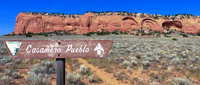
Casamero Pueblo is a Chacoan outlier Great House site located between Grants and Gallup, NM. This two-story Great House was occupied between A.D. 1000 and 1125. It had 22 ground floor rooms and may have had six second-story rooms. It is located 45 miles south of Chaco Canyon, making it a Chacoan outlier community. You can see its walls in the far distance, to the right of the sign, at the base of the bright red sandstone cliffs of Tecolote (Owl) Mesa. The two alcoves just to the right of the sign form the large "owl's eyes" that give the mesa its name. The Great House had T-shaped doorways that are characteristic of Chacoan architecture, one small interior kiva, a great kiva, and two Chacoan roads. Casamero was settled during a time that corresponded with a surge of building in Chaco Canyon – around A.D. 1050. It existed during much of the florescence of Ancestral Pueblo culture in Chaco Canyon, was clearly related to it, and declined in unison with it. When something in...